skip to content
NSW Bushwalking Maps
User Tools
Log In
Site Tools
Search
Tools
Show page
Old revisions
Backlinks
Recent Changes
Media Manager
Sitemap
Log In
>
Recent Changes
Media Manager
Sitemap
Trace:
qgis_qfield
Media Manager
Namespaces
Choose namespace
[root]
wiki
Media Files
Media Files
Upload
Search
Upload to
[root]
Sorry, you don't have enough rights to upload files.
File
View
History
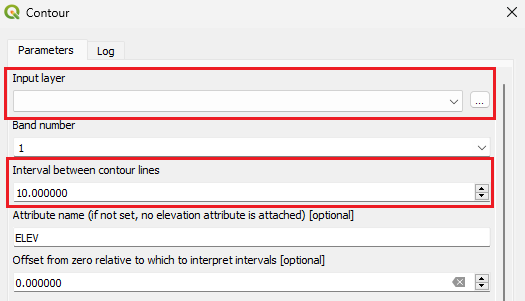
qgis_gdal_contour.png
Date:
2024/05/13 08:05
Filename:
qgis_gdal_contour.png
Format:
PNG
Size:
11KB
Width:
525
Height:
301
References for:
Contours
qgis_qfield.txt
· Last modified: 2023/10/08 21:43 by
bushwalking
Page Tools
Show page
Old revisions
Backlinks
Back to top


![[root]](/wiki/qgis_qfield?ns=&tab_files=files&do=media&tab_details=view&image=qgis_gdal_contour.png)